Cover The view from Yuen Tsuen Ancient Trail. (Photo: Zabrina Lo/Tatler Hong Kong)

Taking you through ancient villages, war ruins and more, these Hong Kong heritage hiking trails are perfect for those looking for a dose of history and adventure

Hong Kong’s countryside is known for its breath-taking views, but from ancient villages to war ruins and rock carvings, it has another mysterious and nostalgic side to offer those looking for summer adventures.

If you want to discover a lesser-known side of the city and get a good dose of history along the way, head out to one of these Hong Kong heritage hiking trails:

Ancient villages

Tatler Asia
Above Yuen Tsuen Ancient Trail. (Photo: Zabrina Lo/Tatler Hong Kong)

Yuen Tsuen Ancient Trail
 
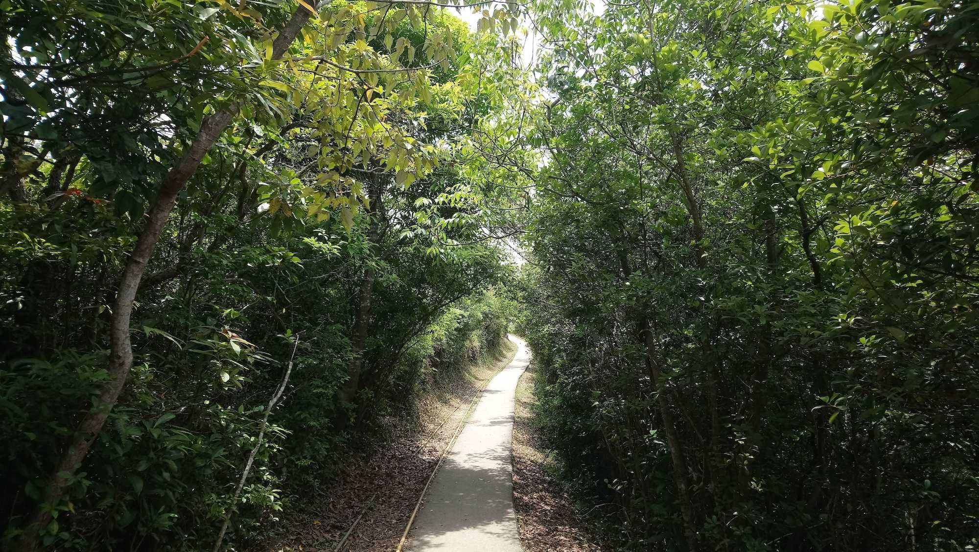
Before it became the well-paved country trail it is today, Yuen Tsuen Ancient Trail used to be the major footpath back in the days when no public transport was available to connect Yuen Long and Tsuen Wan. Villagers had to travel on foot across the hill ranges in Tai Tong and Tin Fu Tsai, which spans around 15km, in order to transport crops.
 
Not much has remained since urban development changed the area’s landscape. Yet along the way, there are still a few huts and family graves, as well as patches of farmland. Near the picnic site in Tai Lam Chung Country Park is Kut Hing Bridge. Currently inaccessible, this small, ancient bridge was the only way for the villagers in the past to cross the river to the other end.
 
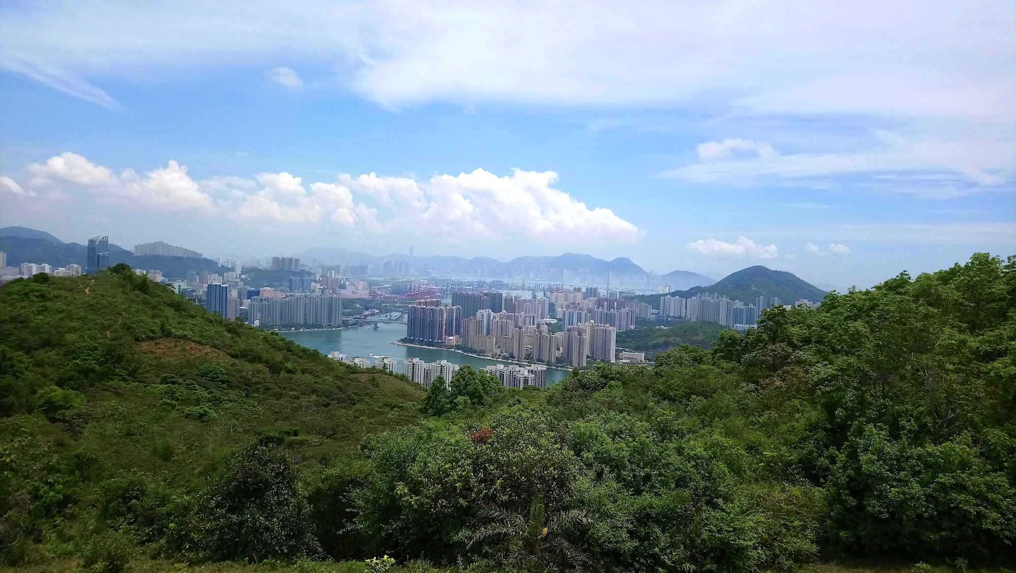
Apart from historical relics, the ancient trail offers a multitude of natural scenery: pristine subtropical forests, a majestic view of Hong Kong’s highest hill Tai Mo Shan, and lush valleys. Upon overlooking the hillside squatter village of tin-roofed huts (a common sight before the 1960s), you arrive in Sham Tseng at the end of the hike. This area is famous for its succulent roasted geese with crispy skins. The family-owned Yue Kee Restaurant was founded in 1958 by Ng Chun Yim, who brought his hometown recipe from Chaozhou. The charcoal-roasted geese are popular among villagers, hikers, tourists and even Michelin food critics.
 
How to get there: To start, hop on to bus 39M, 30, or 30X to Allway Gardens from Tsuen Wan MTR station. Get off at Tsuen Wan Adventist Hospital. Walk uphill along Tsuen King Circuit for a short distance. You’ll find a path with a flight of stairs on the left, which is the start of Yuen Tsuen Ancient Trail.

See also: Hong Kong Hikes—Plus Where To Eat And Drink After

Ping Shan Heritage Trail
 
For those looking for existing ancient architecture, Ping Shan in Yuen Long has everything to offer. The 1.6km trail is the first of its kind to be inaugurated by the Antiquities and Monuments Office and the Architectural Services Department in 1993, making it one of the best-preserved heritage sites in Hong Kong.
 
Ping Shan is dominated by the Tang Clan, a major clan in the New Territories, which traces back to the Northern Song dynasty (960-1127) when Tang Hon-fat, the 86th generation ancestor, moved from Jiangxi to Guangdong Province. Six generations later, Tang Yuen-ching and his family settled down in Ping Shan in the 12th century and became the first generation of the Ping Shan lineage who established “Three Wais (walled villages) and Six Tsuens (villages)”.
 
The Tang people value education and family, as evidenced by the numerous study halls, temples, and ancestral halls they built. In particular, the hexagonal Tsui Sing Lau (“tower for catching stars”) Pagoda houses a statue of Fui Shing, the deity in control of success in examinations. Some of the clan’s traditional customs are retained to this day, including communal worships in spring and autumn, lantern lighting ceremonies for newborn boys, and the Tai Ping Ching Chiu festival every decade.
 
How to get there: Ping Shan Heritage Trail is a short walk from Tin Shui Wai MTR station.

War ruins

Pinewood Battery Heritage Trail
 
Overlooking the eastern waters, the Pinewood Battery was the highest coastal defence battery in Hong Kong at 307 metres above sea level. It was completed in 1905, and converted into an anti-aircraft battery during WWI with the advent of air power. Then at the Battle of Hong Kong in December 1941, it was heavily shelled by the Japanese artillery fire from the captured Kowloon Peninsula, leaving it abandoned after WWII.
 
Today, the war relic is a part of Lung Fu Shan Country Park. The 0.4km heritage trail starts at the entrance of the Picnic Area Site No.1 on Hatton Road, passing by 12 ruins, including bunkers, a command post, gun platforms, as well as emplacements.
 
How to get there: Take bus 13 to the junction between Kotewall Road and Hatton Road. Walk uphill along Hatton Road for about 1.5 km.

Lamma Island

Another trace of WWII are the kamikaze grottos which can be found along the coast of Sok Kwu Wan on Lamma Island. The grottos are ten metres wide and several tens of metres deep. Back then, thousands of Japanese soldiers took hold of Lo So Shing. They dug these tunnels to hide speedboats loaded with explosives, which were planned for suicidal attacks on the Alliance’s fleets if they passed by, which explained the name of the grottos – kamikaze “god-wind” soldiers attacked enemies knowing that they will be killed doing it. However, the war ended before their work was completed.

Some of the caves have been sealed up by villages. A few of the rest are now home to bats and Romer’s tree frogs, which are endemic to Hong Kong and are the smallest amphibian recorded in the territory.

How to get there: Take the ferry to Sok Kwu Wan from Central pier 4. The 45-minute walk between Sok Kwu Wan and Yung Shue Wan is well-paved, and there is a wide selection of seaside cafes and seafood restaurants to end your journey at.

See also: Island Guide: What To Eat, Drink And Do In Lamma Island

Rock carvings

Tatler Asia
Above The rock carving that can be found at Tung Lung Chau. (Photo: Kit Chau)

Tung Lung Chau
 
The largely uninhabited island in Sai Kung has the largest carving in Hong Kong, measuring 1.8m by 2.4m. It is also the earliest carving found in-situ in the territory, dating back to approximately the Chinese Bronze Age 3000 years ago. A Qing dynasty entry in Xinan Gazetteer (1819) compiled by Wang Chong Xi mentions that the impression depicts a dragon.
 
Aside from the rock, the island is also home to Tung Lung Fort. Built in 1719, it protected trades and fended off pirates. Rumour has it that it was attacked by pirates Cheng Lien Chang, Cheng I, and more recently by the most notorious of all, Cheung Po Tsai. In 1810 when its personnel moved to another fort at the tip of the Kowloon Peninsula (later Kowloon Walled City), the fort was abandoned.
 
How to get there: The remote island isn’t the easiest to reach, as ferries to the island operate only weekends and public holidays. The ferry is operated by Coral Sea Ferry Services Company Limited and travels between Tung Lung Chau and Sam Ka Tsuen. The closest MTR station to Sam Ka Tsuen pier is Yau Tong in Lei Yue Mun. After you have taken the ferry, upon arriving at Tung Lung Chau pier, hikers then have to walk for around 40 minutes to the site. Do check the transportation before you set off to avoid getting stranded on the island, though if you plan on spending the night, it’s one of the prettiest sites for camping and stargazing.

Tatler Asia
Above The "Palm of Buddha" — a hand-shaped feature carved into the face of a cliff by the elements, which is one of the most recognisable landmarks of Po Toi. (Photo: Getty Images)

Po Toi Island
 
Further down south on Po Toi Island another set of rock carvings can be found. This one – found on a cliff in Nam Tum – is also around 3000 years old and a declared monument, but unlike those on Tung Lung Chau, this set features totem patterns. Some scholars suggest that they are stylized animals and fish. The carvings have faded considerably due to weathering, and are currently projected behind a sheet of glass.

Po Toi Island is also known for its geological features, including “Palm of Buddha”, “Monk Rock” and “Tortoise Rock” – all peculiar-looking artworks carved by nature. Morever, you can overlook the majestic view of South China Sea from the still active Lighthouse 126, and savour the local seafood and seaweed soup.

Hot to get there: The 4km hike takes around 2.5 hours. To reach Po Toi Island, take a kaitoferrie from either Aberdeen or Stanley Pier to Po Toi Pier.

See also: Hong Kong Hikes: The Best Trails On The Outlying Islands

Topics